- Printed on Regular Paper (32lb)
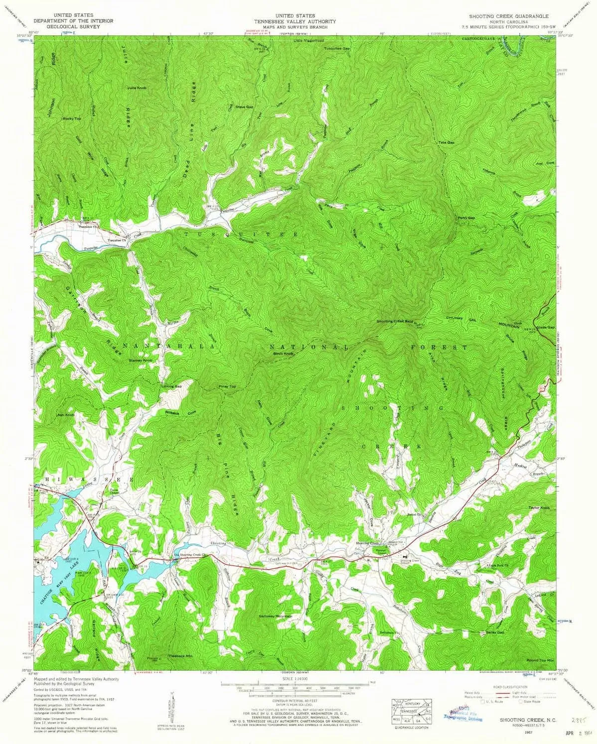
- USGS topographic map of Shooting Creek, NC, at 1:24000 scale. High-quality paper print. Perfect for wall maps.
- Cities, towns, villages: Elf,Shooting Creek
- Rivers, creeks: Hurricane Creek,Thumping Creek,Burch Cove Branch,Compass Creek,Julie Branch,Muskrat Branch,Pounding Mill Creek,Cold Branch,Moss Branch,Chairmaker Branch,Stillhouse Branch,Mill Creek,Lynch Branch,Sapsucker Branch,Big Tuni Creek,Church Branch,Sunday Branch,Nattie Branch,Bluff Branch,Little Tuni Creek,Eagle Fork Creek,Ledford Creek,Vineyard Creek,Needmore Branch,Cherry Cove Branch,Perry Creek,Steve Branch,Davenport Branch,Shooting Creek,Locust Log Branch
- Lakes: Consult topo map preview for bodies of fresh water.
USGS topographic map of Shooting Creek, North Carolina, dated 1957, updated 1964.
Includes geographic coordinates (latitude and longitude), lines of elevation, bodies of water, roads, and more. This topo quad is suitable for recreational, outdoor uses, office applications, or wall map framing.
Printed on-demand by YellowMaps on the print material of your choice.
Shipping rolled from Minneapolis, MN, United States.
Product Number: USGS-5373266
Map Size: 26.8 inches high x 21.8 inches wide
Map Scale: 1:24000
Map Type: POD USGS Topographic Map
Map Series: HTMC
Map Version: Historical
Cell ID: 41165
Scan ID: 164925
Imprint Year: 1964
Woodland Tint: Yes
Aerial Photo Year: 1953
Field Check Year: 1957
Datum: NAD27
Map Projection: Polyconic
Map published by Tennessee Valley Authority
Map Language: English
Scanner Resolution: 600 dpi
Map Cell Name: Shooting Creek
Grid size: 7.5 X 7.5 Minute
Date on map: 1957
Geographical region: North Carolina, United States
Northern map edge Latitude: 35.125°
Southern map edge Latitude: 35°
Western map edge Longitude: -83.75°
Eastern map edge Longitude: -83.625°
Surrounding map sheets (copy & paste the Product No. in the search bar):
North: USGS-5373732,USGS-5373730,USGS-5373736,USGS-5373734
East: USGS-5372752,USGS-5372756,USGS-5372754,USGS-5372758,USGS-5372750
South: USGS-5363398,USGS-5363402,USGS-5362794,USGS-5363400,USGS-5362792
West: USGS-5370948,USGS-5370954,USGS-5370946,USGS-5370950,USGS-5370958


")


