- Printed on Regular Paper (32lb)
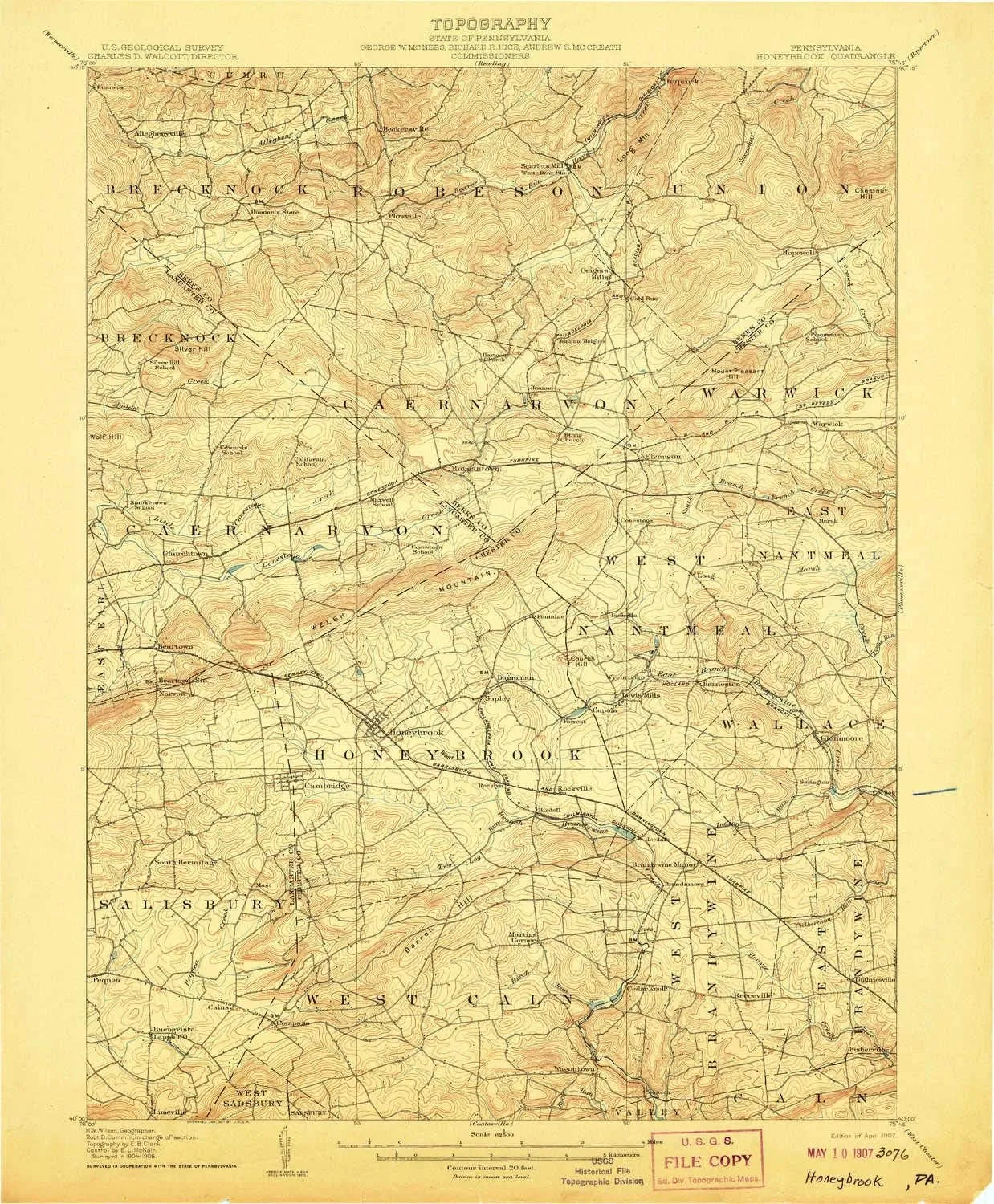
- USGS topographic map of Honeybrook, PA, at 1:62500 scale. High-quality paper print. Perfect for wall maps.
- Cities, towns, villages: Church Hill,Fontaine,Rockville,Martins Corner,New Morgan,Pine Swamp,Mountain Top,Brittany Estates,Churchtown,Morgantown,Rocklyn,Isabella,Warwick,Cedar Knoll,Fisherville,Maple Grove Park,Guthriesville,Glenmoore,Cupola,Compass,Siousca,Scarlets Mill,Joanna,Wagontown,State Hill,Cains,Loag,Pennwood Farms,Geigertown,Briarwood,Suplee,Conestoga,Lewis Mills,Joanna Furnace,Honey Brook,Trythall,Icedale,Alleghenyville,Narvon,Wyebrooke,Cornog,Little Washington,South Hermitage
- Rivers, creeks: East Branch Conestoga River,Scotts Run,Two Log Run,Lyons Run,North Branch Indian Run,West Branch Conestoga River,Indian Run,Sleepy Hollow Run,Little Conestoga,Indian Spring Run,Pine Creek,Beaver Run,Birch Run
- Lakes: Jones Millpond
USGS topographic map of Honeybrook, Pennsylvania, dated 1907, updated 1907.
Includes geographic coordinates (latitude and longitude), lines of elevation, bodies of water, roads, and more. This topo quad is suitable for recreational, outdoor uses, office applications, or wall map framing.
Printed on-demand by YellowMaps on the print material of your choice.
Shipping rolled from Minneapolis, MN, United States.
Product Number: USGS-5330368
Map Size: 20 inches high x 16.5 inches wide
Map Scale: 1:62500
Map Type: POD USGS Topographic Map
Map Series: HTMC
Map Version: Historical
Cell ID: 55439
Scan ID: 167873
Imprint Year: 1907
Survey Year: 1905
Datum: Unstated
Map Projection: Unstated
Map published by United States Geological Survey
Map Language: English
Scanner Resolution: 600 dpi
Map Cell Name: Honey Brook
Grid size: 15 X 15 Minute
Date on map: 1907
Geographical region: Pennsylvania, United States
Northern map edge Latitude: 40.25°
Southern map edge Latitude: 40°
Western map edge Longitude: -76°
Eastern map edge Longitude: -75.75°
Surrounding map sheets (copy & paste the Product No. in the search bar):
North: USGS-5327156,USGS-6088461,USGS-5331362,USGS-5331360,USGS-5331364
East: USGS-5323374,USGS-5331206,USGS-5331198,USGS-5323376,USGS-5331190
South: USGS-5390404,USGS-5931071,USGS-5329756,USGS-5390394,USGS-5329750
West: USGS-5326364,USGS-5326358,USGS-5332032,USGS-5326356,USGS-5332034


